Our drive to Benson, AZ was pretty straight-forward, except it was very windy, and the RV really feels the wind. Especially when driving along the interstate highways. Once we set up at Valley Vista RV park, I did the laundry, actually with Peter's help this time, while I went to the local Safeway grocery store. After putting away the groceries, and the clothes, we decided to go into "town" for dinner. We found a nice Mexican restaurant, where the food was plentiful and really good, and inexpensive. Since it was early, and Saturday night, we decided to out for a beer. We asked the waitress to recommend a place, and we ended up at the Arena Bar. We walked in, and noticed there were many buckets and even a water trough around the floor. It turns out the roof really leaks a lot. OK, a very local place. There were a few folks in the the bar. We started chatting up the bartender. It turns out he was an ex-army tank driver. Then a satellite communications army person. So, Peter and he ended up talking tanks for quite awhile. They both had fun. And, I had a great local beer, called Kilt Lifter.
The town of Benson is near places to see, but itself is a small Arizona Sonoran desert town. I am impressed with how relatively green the area is, considering it is a desert.
Valley Vista RV park photo:
Sunday, February 23, 2020
Friday, February 21, 2020
Feb 21 - Picacho Peak State Park, Picacho, AZ
Cool and very windy cloudy day. Hung out in the morning. I actually started working on tax return preparation. We had lunch, and headed out. We went to Picacho Peak State Park, about 40 minutes away. This area is very, very flat. With scrub bushes and saguaro cacti all over. It is actually somewhat green, versus the dry desert sand of elsewhere in Arizona. Sprouting up from the flat areas are these small mountain ranges, scattered hither and yon along the horizon. Picacho Peak is one such range. The park has trail heads leading up to the top, as well as along the front face of the range.
We hiked the Calloway Trail. This was about 2 miles, round trip. However, it was a very steep climb up. They did have nice stone steps along the way. Once at the top of the trail, about 2,274 feet, there was a nice bench and overlook of the valley floor below. We sat and enjoyed the view for awhile. I was pleased to see flowering plants along the trail. Beautiful yellow poppies, various purple and little white ones. So, there must be water in the area. And, in fact, the entire side of the mountain range was green, instead of the slate black of a lot of other mountains around here.
Very nice hike.
Picacho Peak State Park photos:
We hiked the Calloway Trail. This was about 2 miles, round trip. However, it was a very steep climb up. They did have nice stone steps along the way. Once at the top of the trail, about 2,274 feet, there was a nice bench and overlook of the valley floor below. We sat and enjoyed the view for awhile. I was pleased to see flowering plants along the trail. Beautiful yellow poppies, various purple and little white ones. So, there must be water in the area. And, in fact, the entire side of the mountain range was green, instead of the slate black of a lot of other mountains around here.
Very nice hike.
Picacho Peak State Park photos:
Feb 20 - Casa Grande Ruins National Monument, Coolidge, AZ
We spent the morning on the computers. Me updating, finally, my blog and Peter doing his Forbes blog and Margaret Fuller Documentary stuff. After lunch, we drove to the Casa Grande Ruins National Monument. They had a really good film about the ruins, then a guided tour by a rather knowledgeable volunteer guide. The ruins were built around 1350, and were a 3 story earthen structure, surrounded by a walled village. The building was constructed by the Hohokam, proficient desert farmers who built hundreds of miles of canals to irrigate their crops. The engineering of this building was impressive, as it took massive amounts of clay-type mud, and wood poles from far away, as was 3 stories high. They had a thriving trade route. Shortly after the Casa Grande was built, they abandoned the village, for reasons unknown. The history of the area was very interesting. We were told that the Sonoran desert is actually full of edible food, year-round, if you know what you are looking for. And, if you settle by the rivers that flowed year-round, you could survive and farm. This area actually grew, and continues to grow, cotton. Which takes a lot of water to grow.
We returned back to the campgrounds, and I went swimming in their pool, and then used the hot tub. Ah, how relaxing. Dinner, then we watched the John Wayne movie, Fort Apache, which was shot here in Arizona.
Casa Grande National Ruins photos:
We returned back to the campgrounds, and I went swimming in their pool, and then used the hot tub. Ah, how relaxing. Dinner, then we watched the John Wayne movie, Fort Apache, which was shot here in Arizona.
Casa Grande National Ruins photos:
Thursday, February 20, 2020
Feb 19 - Travel to Casa Grande, AZ
We left fairly early, and drove down through Phoenix, to Casa Grande, AZ, about an hour further south. Definitely out in the Sonora Desert. Not much here, several mountains ranges on the edges of the very flat plains. Our Foothills West RV Resort is NOT where I would come to spend the winter. However, it looks like a lot of people do. This RV park is mostly annual folks, who build on to their RV's to make it semi-permanent. There are some big RV's here for shorter times, and a few, like us, just traveling through. It feels like a mobile home trailer park. It is very clean, and has a nice pool and hot tub. And the weather is beautiful.
I did the laundry, which is right across from our site. Then, went into the local Fry's grocery store to pick up a few items, and then made dinner. By then, I was tuckered out. We watched an episode of Star Trek: Deep Space Nine.
No photos today.
I did the laundry, which is right across from our site. Then, went into the local Fry's grocery store to pick up a few items, and then made dinner. By then, I was tuckered out. We watched an episode of Star Trek: Deep Space Nine.
No photos today.
Feb 18 - Cottonwood, AZ historic old town, and Montezuma Castle
Our Valley Verde campgrounds have no WiFi that works, and our cell phone and internet coverage was non-existent. So, we went into Cottonwood, to a Starbucks, and sat and had coffee and worked on our computers. For lunch, we went into the Cottonwood Old Town, and had lunch at a nice little cafe.
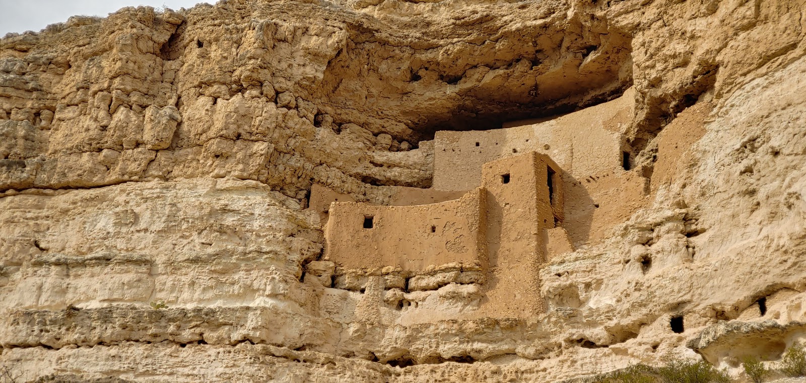
For our daily excursion, we went to Montezuma Castle, in nearby Camp Verde, AZ. These are ruins of native "apartments" built into the side of one of the mountains, overlooking a little river. It is a 5 story, 20 room dwelling, built between 1100 and 1300. I occupies a cliff recess 100 feet above the valley. Early American settlers assumed that it was Aztec in origin, so they called it Montezuma Castle. Interesting.
We returned to the campground, just in time for me to get a Hangouts call from Owen, for his 3rd birthday! I got to watch him open his birthday presents from me (until the Hangouts call blanked out, due to lack of cell service).
Montezuma Castle photos:
Owen's 3rd Birthday photo:
For our daily excursion, we went to Montezuma Castle, in nearby Camp Verde, AZ. These are ruins of native "apartments" built into the side of one of the mountains, overlooking a little river. It is a 5 story, 20 room dwelling, built between 1100 and 1300. I occupies a cliff recess 100 feet above the valley. Early American settlers assumed that it was Aztec in origin, so they called it Montezuma Castle. Interesting.
We returned to the campground, just in time for me to get a Hangouts call from Owen, for his 3rd birthday! I got to watch him open his birthday presents from me (until the Hangouts call blanked out, due to lack of cell service).
Montezuma Castle photos:
Owen's 3rd Birthday photo:
Feb 17 - Sedona, AZ
What an incredible place is Sedona! I loved the red rock formations, and the mountains and canyons. Unfortunately, we didn't realize it was a holiday-Presidents Day. So it was very crowded. And, we put in the GPS the Red Rock Visitor Center. What we didn't realize is that there is a Red Rock State Park and a Red Rock Ranger Station Visitor Center for the National Forest. Both in different locations. Actually, it was fortunate that we ended up in the National Visitor Center, as they gave us a great map of the entire area with all of the rock formation areas shown on it. They also gave us a suggested route to see them. We drove the main road, past Bell Rock and Courthouse Butte, but the parking areas were all full, so we couldn't stop there to hike. We ended up a little further down the road, at the Little Horse Trailhead. We did a 3 mile round trip hike, past Bell Rock, into a canyon that ended up being right across from the Chapel of the Holy Cross. This is a church built right up into the mountain, with an amazing vista. The hike was incredible. One amazing formation after another.
Next, we drove to the other side of the canyon and went up to the Chapel of the Holy Cross. Again, the parking lot was full, so we just drove to the top and back down again. The drive itself had great views. By this time, it was getting to be lunch time. We decided to go to the Tlaquepaque Art & Shopping Village, in the middle of Sedona, to see the galleries and eat at the Mexican restaurant. However, there was a 40 minute wait, so we just meandered through the shops, and found a different nearby gallery plaza and ate lunch outside.
The next stop was Airport Mesa Overlook, where the "Vortex" is located. This road drove up a mountain range overlooking the entire Sedona valley.
The final area we explored was Dry Creek Road, to Boynton Canyon Road, ending up at the Enchantment Resort. We stopped at the Long Canyon Trailhead, and did a mile hike there. Again, the various rock formations, the beauty of the mountains, and the colors were breathtaking. We ended up at Enchantment Resort around 5 pm. This resort is very upscale, with rooms going for $300 to $1,000 per night. However, they do have a public restaurant and a public bar, with outside seating, overlooking a mountain side. At sunset, the mountain is all lit up. So, we sat and had a beer, and enjoyed the view. The way back, down the canyon, was also lit up with the setting sun. What an amazing day!
Little Horse Trail photos:
Airport Mesa photos:
Dry Creek Rd, Boynton Canyon Rd and Long Canyon Trail photos:
Enchantment Resort photos:
Next, we drove to the other side of the canyon and went up to the Chapel of the Holy Cross. Again, the parking lot was full, so we just drove to the top and back down again. The drive itself had great views. By this time, it was getting to be lunch time. We decided to go to the Tlaquepaque Art & Shopping Village, in the middle of Sedona, to see the galleries and eat at the Mexican restaurant. However, there was a 40 minute wait, so we just meandered through the shops, and found a different nearby gallery plaza and ate lunch outside.
The next stop was Airport Mesa Overlook, where the "Vortex" is located. This road drove up a mountain range overlooking the entire Sedona valley.
The final area we explored was Dry Creek Road, to Boynton Canyon Road, ending up at the Enchantment Resort. We stopped at the Long Canyon Trailhead, and did a mile hike there. Again, the various rock formations, the beauty of the mountains, and the colors were breathtaking. We ended up at Enchantment Resort around 5 pm. This resort is very upscale, with rooms going for $300 to $1,000 per night. However, they do have a public restaurant and a public bar, with outside seating, overlooking a mountain side. At sunset, the mountain is all lit up. So, we sat and had a beer, and enjoyed the view. The way back, down the canyon, was also lit up with the setting sun. What an amazing day!
Little Horse Trail photos:
![]() |
| Bell Rock |
![]() |
| View of the Chapel of the Holy Cross
In the Tlaquepaque Art Village photo (next to Emelia Earhart):
|
Dry Creek Rd, Boynton Canyon Rd and Long Canyon Trail photos:
Enchantment Resort photos:
Feb 16 - Drove up to Cottonwood, AZ, stopping at Arcosanti
Our trip up to Cottonwood was fairly short and easy. We passed right by the community of Arcosanti, so we stopped to visit. This is a community started in the 70's by Paolo Solari, an architect who wanted to create an urban alternative integrating architecture and environmental concerns. He created an "arcological" community located on a mountainside in the desert of Arizona. Fortunately, there was water available. We didn't do the tour, but did talk with a few members. The key item to their continued existence as a community, in my opinion, is that they created a significant economic base. They manufacture and sell Arcosanti Bells. Metal bells of all sizes and shapes, that has developed into a multi-million dollar business. The issues the community faces are SO reminiscent of my experience at Sirius. The strong leader, Solari, died awhile back, leaving no strong leadership in place. His idea of attracting 5,000 members, then 500 members, and the actual 60 members is telling. They have good internship programs in partnership with many universities and architectures. But, I would NOT want to live there--so dry, desert, hours from urban life. Not the place I would choose to show an urban-alternative. BUT, it was very interesting.
We arrived at Verde Valley RV resort, in Cottonwood, AZ, about half hour south of Sedona. This is the largest Thousand Trails campground we have been to. It is spread out over the top of a mountain (hill) side, and also along the base of the mountain (hill). Great vistas from the top.
No internet or cell phone coverage though. So, it was a nice evening of reading. The stars at night were amazing.
Arcosanti photo:
Valley Verde campground photos:
We arrived at Verde Valley RV resort, in Cottonwood, AZ, about half hour south of Sedona. This is the largest Thousand Trails campground we have been to. It is spread out over the top of a mountain (hill) side, and also along the base of the mountain (hill). Great vistas from the top.
No internet or cell phone coverage though. So, it was a nice evening of reading. The stars at night were amazing.
Arcosanti photo:
Valley Verde campground photos:
Subscribe to:
Posts (Atom)