Sunday, December 1, 2019

Nov 16 - 20, Visiting Robbie & Ann, Long Beach, California & Bob & Jane, Claremont, CA

  Our final stop before flying home was a wonderful visit with Robbie and Ann, in Long Beach, California, at their new home on the canal.  They are wonderful hosts, and showed us the many sites of the area.  We went for Duffy boat rides on their canal,  kyaked and paddle boarded around the canal, and went to the ocean to Huntington Beach, to watch the surfers.  That day was a very warm, sunny day, and a friend of theirs was surfing.  We walked the local Long Beach town and shops and went out on the Belmont pier.  I even went to Robbie's hairdresser and got a new cut and highlights!  After 5 months in the boonies, it felt great.
  We also took our car over to cousin Bob & Jane's house in Claremont, CA.  They have a big driveway, and have allowed us to leave our car there for the duration.  We spent a very enjoyable afternoon and evening chatting and having dinner.  They have a very nice outdoor fire pit, which is so very conducive to hanging out and chatting.
  What a wonderful way to end our 2019 Western RV road trip.

Various Robbie & Ann photos, Long Beach, California:


Dinner at Bob & Jane's photos:


Friday, November 29, 2019

Nov 15 - Acton, CA

  We drove to our final destination on this fantastic westward RV journey - Acton, California.  This is a Thousand Trails RV resort, that is huge, about 1 hour from Los Angeles, up in the foothills of the San Gabriel mountains.  This resort has an RV storage, so this is where we will leave our RV while we visit with Robbie and Ann, and then fly home for Thanksgiving and Christmas. 
  The landscape here is really DRY and dusty.  No water in the 3 dry stream beds flowing through the park.  Nice view of the surroundings mountains. 
  We spent the day getting the RV ready for storage, packing our warm clothes for the days spent in Long Beach, and the cold weather clothes for our trip back home.  We ate dinner, trying to empty our our refrigerator, as it needed to be cleaned and turned off. 
  We met a fellow RVer, who was a professional Santa Claus impersonator.  Fun!

Soledad Canyon RV Park, Acton, CA photos:


Thursday, November 14, 2019

Nov 14 - Day off in Lemon Cove, California

  We needed a day off, to catch up on our blogging, do the laundry, and start getting things ready for our RV storage of 2 months.  Took a nice walk around the campgrounds.  Otherwise, just "taking care of things".

No photos today.

Nov 13 - Kings Canyon National Park, California

   We decided to enter Kings Canyon National Park from the north entrance, off of Hwy 180, instead of driving back through Sequoia National Park to the northern road, that connects with Kings Canyon.  We figured it might be less windy, according to the map.  WELL.  We took Highway 245 from our road Highway 198 up to Highway 180.  It was around 40 miles.  AND IT WAS ALL TWISTY, CURVY, SWITCHBACKS.  Going 10 to 20 mph takes a long time to drive 40 miles.  I have NEVER driven such a windy road for so long.  And, since it was a local road, there were no turnouts and overlooks to stop at.  No shoulders.  Just focus on the curvy road and drive--for a long time!  We actually went through two "towns" along the way--population 240 and 345.  I can't imagine living so remotely, on the mountain sides, and have to drive that road every time you need to go anywhere.
   We got to the Kings Canyon National Park entrance, and decided to only go to two places--the General Grant Sequoia Tree Grove and the Panoramic Point.
   General Grants Grove was a nice 1 mile loop, through this very nice Giant Sequoia grove.  Half way through the loop is the General Grant Tree.  One of the largest trees in the park.  It's diameter is 40 feet, and it is 248 feet tall.  They also had a hallow,  downed tree that early workers used to live in.  And many other huge, magnificent, and noble trees. It's nice to see that the National Parks are taking such good care of our incredible resources.
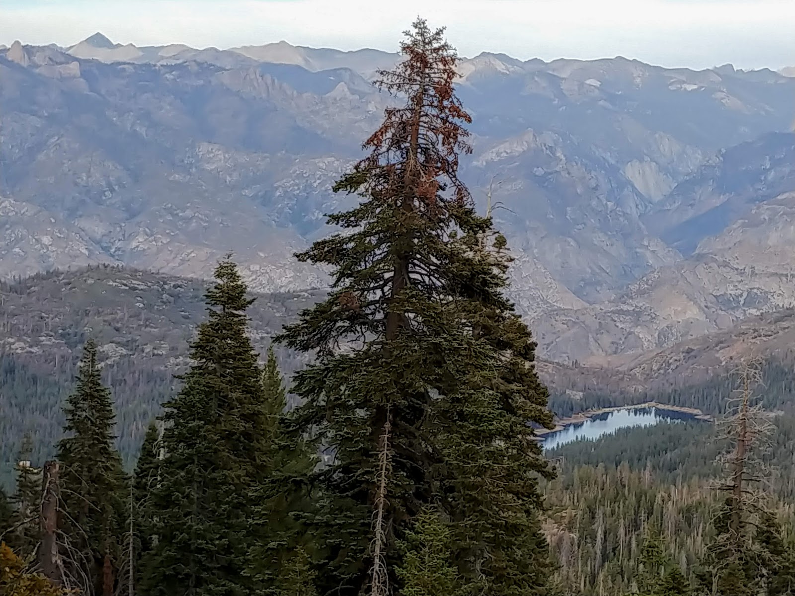
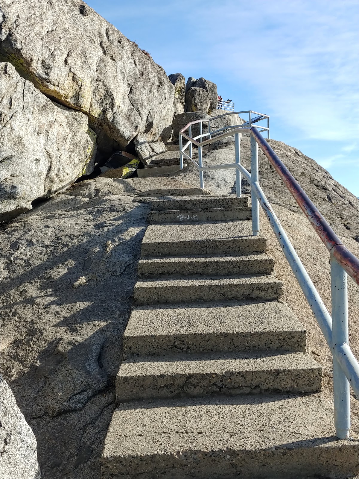
  We then drove up the 2 miles curvy, winding, steep road to the Panoramic Point.  This was a short hike up the  hill, on a paved trail, to a phenomenal overlook of the entire Kings Canyon.  The high Sierra's in all their glory.    Breathtaking.  We sat on a bench and took it all in.
  We were very clear that we wanted to go back to the RV on a different route.  So we took Hwy 180 further west, to Hwy 63, and then south to the town of Visalia.  We had dinner at a really neat brewery.  The restaurant was right next to the brewing tubs.  Good beer too.  We drove the 20 miles back on Hwy 198 to the RV site.  A bit longer route, with swerves, but a much easier trail.  Took us about the same amount of time.

Kings Canyon photos:

General Grant Grove photos:


Panoramic Point photos:


Brewery restaurant photo:

Nov 12 - Sequoia National Park, California

  Our last National Park before we end this leg of our RV travels is Sequoia National Park and Kings Canyon National Park.  Today's journey was just to Sequoia National Park.  Our campground is about 20 miles from the park.  Once in the park, the main attractions are giant Sequoia Redwood groves and mountain peaks and vistas in the Sierra Nevada mountain range.    The Sequoia Redwoods only grow in a very specific environment, from 4,000 to 7,000 feet, where it is not too cold or too wet.  They thrive on the west side of the mountains.  Fortunately, the weather has been warm, so far.  They tell me there is usually snow already in the mountains, and many roads are usually already closed.
   Our whole drive today was only about 454 miles inside the park, but at 10 - 25 mph, it takes a while to drive it.  Lots of steep, winding roads and switchbacks with beautiful overlooks. Here's a summary of our stops:

  • Hospital Rock - just an unusual rocky outcropping, that has the remains of native handprints on the rock wall. 
  • Outlook - at one of the switchbacks there was a nice view of the Great Western Divide. Per Wikipedia, the Great Western Divide is a Sierra Nevada mountain range that forms part of the border between the Kings Canyon and Sequoia National Parks. Some of the summits of the Great Western Divide reach well over 13,000 feet .  We sat on a rock bench and ate our picnic lunch watching the incredible vista.  It had a great view of Castle Rock (pinnacles) and Moro Rock (dome).
  • The Giant Forest Museum and the Big Trees Loop Trail - the Museum was interesting, and taught a lot about the Redwoods.  How and where they grow, the need for fire periodically, the way their roots grow etc.  We took a 1 mile loop trail around a wetland meadow (at least wet in the spring and summer--it was dry now).  This is the perfect environment for the huge Sequoia Redwoods to grow.  Very majestic and regal are these trees.  They are wider and bigger than the ones in the northern California Redwood groves.   Nice hike through the many trees in this grove.
  • Moro Rock - this rock is 6,725 feet tall.  We drove a narrow road to an access trail up to the peak of this rock.  Since the 30's, they have been climbing up to the summit.  Since then, they have installed stairs-312 of them, along with ramps, and hand rails, so the trail up to the top is "safe".   When Peter and I started climbing the stairs up, we had no idea how steep, and how high they were going.  I was determined to get to the top.  As long as I just looked at the stairs in front of my feet, and not at the vista, I was OK.  Slow and Steady, climb, climb, stop and look--Oh MY!!  Climb some more.  Are we almost there yet?  Still more stairs?  Really?  Just around the next couple of switchback stairways the folks coming down said.  Several times.  At one point, 3/4 of the way up, Peter had enough.  So I went on.  I am SO GLAD THAT I DID.  I have never been to a mountain peak of 6,725 feet before.  The top was a narrow platform ridge, with railing all around, overlooking the Sierra Nevada mountain range.  What a view!  Just the fact that I was able to actually climb up it, made my day.  But for me, this was the highlight of the day!
  • Tunnel Log - a bit anticlimatical after the Moro Rock climb, but this is a log that is so big, they carved out a tunnel in it for the cars to go through.  They don't allow that to happen anymore, at it is now not politically correct (or ecologically sound).
We took the road home, slow and steady.  Going down the mountains seemed a bit easier.  Very nice day.

Sequoia National Park photos:

Hospital Rock, Tunnel Rock, Outlooks photos:


Big Tree Loop Grove photos:


Moro Rock photos:


I made it to the TOP !!


Peter waiting for me, 3/4 of the climb up

Tunnel Log photos: