Tuesday, October 5, 2021

Oct 3 - Lower Antelope Canyon Tour, Page, UT

   Today we had a 3:15 pm tour scheduled for the Lower Antelope Canyon, so we hung out for the morning and early afternoon.  Walked around the campground, which is bigger than I thought.  Then headed out for the tour.  

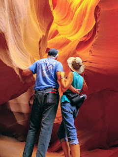
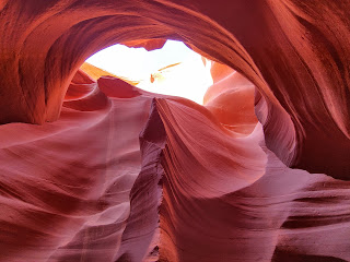
   This slot canyon was even more impressive than yesterday's canyon!  It was more organized, from a tourist perspective.  We have been very impressed with the Covid standards dictated by the Navajo Nation.  Everyone on the tour, which was limited to 7 in each group, needed to wear a mask at all times, even when taking pictures, and they took our temps upon arrival.  The lower canyon apparently is narrower than the upper canyon.  Our young Navajo guide was fairly new, but was a very capable and informative guide.  These tours are not as educationally focused as the Nat Geo or the Road Scholar tours.  The guides didn't know the geology details, or the history of the Navajo nation.  But, they knew the canyons.  This guide pointed out all of the images/animals/people in the rock formations.  It reminded me of looking at the clouds and finding all of the images in the cloud formations.  He also was very willing to tell us where the best photo shots were, and to take photos of us, as well as to show us how to get certain images on our cameras.  But the canyon was AMAZING.  We really, really liked these formations and the many, vibrant colors.  Again, the power of water on sandstone, and the beauty of nature.  Many famous photos have been taken of this place.

   After this, we drove over to the dam again, as I wanted to walk across the bridge.  It is big and long, and I wanted to see the view of the dam closer up.  The Visitor Center is right there, which was closed, but also afforded great views of the dam and the Colorado River.  

Lower Antelope Canyon phots (lots):


Glen Canyon dam photos:


Setting sun and reflection on Colorado River below the dam


Monday, October 4, 2021

Oct 2 - Waterhole Canyon, Glen Canyon Dam overlook, and Wahweap scenic drive, Page, AZ

    We had a relaxing morning, since we had a 12:30pm tour scheduled.  The Waterhole Canyon was created by tributaries from the Colorado River, over the last many years.  A group of Navajo families own the tour company that is allowed to give tours of this canyon, which is on the Navajo reservation.  A young Navajo woman was our tour guide for the 2 hour tour, which included 2 separate slot canyons.  The tour included 10 or more step ladders, going down, further into the canyons.  Some were rather challenging.  We have NEVER seen anything like these slot canyons.  They were absolutely remarkable.  Narrow, sometimes allowing only one person through, twisting and turning, beautiful swirls in the rock formations.  Sand covered some of the rocks, so you sort of slid down some of the openings.  Each area was amazing.  And the red, orange and sometimes purple colors, depending on the light, were delightful.  Walking through those canyons, which you can't even tell are there from the prairie, is like being in another world.  It is SO different from the Grand Canyon or the Utah erosion canyons.  These don't have layers in the sandstone rock, just incredible forms created by water.  

   After the tour, we drove over to the Glen Canyon Dam Overlook.  We didn't realize that in order to get to the overlook, you needed to park the car and walk down, down, down to it.  But, it was worth it.  Great view of the dam and Colorado river.  

  We continued to the Glen Canyon National Recreation area, that encompasses all of Lake Powell.  We just drove on the scenic rim drive, up to Wahweap marina and overlook. It was really great to see water again, and the view from the rim was great.  

Lots of photos of Waterhole Canyon tour:


Glen Canyon Dam Overlook photos:


Glen Canyon Recreation Area Scenic Drive around Lake Powell, including Wahweap Overlook photos:


Sunday, October 3, 2021

Oct 1 - on to Page, Arizona, Horseshoe Bend and Antelope Point Marina

   Our trip over to Page, AZ was quite nice.  Mostly dry, prairie with scrub bushes.  Following a line of mountain ranges, either close by or in the distance.  As we approached Page, there was this beautiful outcropping of formations, out from the main range.  But what was so striking was the color.  They were purple, with white layered stripes.  We were going too fast  to stop and there were no turn outs.  So, I just appreciated them.

   We set up in our RV campground, another parking lot -- entirely gravel with a tree at each site for some shade.  The weather is a comfortable sunny 70's day.    We then decided to go exploring.  I first tried to get a tour of the Upper Antelope Canyon, as that is the only way you can access the canyon--with a Navajo tour group.  However, all of the tours were booked for this weekend.  So I found a tour for Sunday, late afternoon, for the Lower Antelope Canyon.  These two canyons are the ones where the famous photos are taken, showing red, swirly sandstone in slot canyons.   We stopped first at the visitor center, and was given the name of another slot canyon tour --the Waterhole Canyon, and so made a reservation for Saturday.  

   We drove to the nearby Horseshoe Bend trail and overlook.   This was a half mile hike out to the canyon rim.  But as you walk the trail, along the prairie, unless you knew there was a steep canyon ahead, you wouldn't know it was there.  But once there, what a view!  This is an oxbow bend in the Colorado River, similar to the one at Dead Horse Point in Utah.  Incredible view.  Only after looking down into the canyon bottom for a bit do you realize that those tiny images are kayakers and a few tents at the bottom.  

  Next, we drove out to Antelope Point Marina.  Lake Powell is a very long, narrow lake, created by a big dam here in Page in the 60's.  It has lots of several wide areas and many more narrow ones.  This marina was on a narrow, almost river-like portion.  It also has a floating restaurant.  In order to get to the restaurant, you have to walk down a long, 1/4 mile steep metal ramp, down to the water.  We had a very nice dinner out on the patio, overlooking the water.  In order to get back up to the parking area, we needed to call the complimentary ATV rides.  The one that came for us had the passenger seat on the back, looking backwards. Well, when it started to ascend the steep road, we really needed to hold on, or we would have fallen off.  Then, on the steepest part of the road, the engine just quit.  After backing up and trying several times, with the engine failing each time, and the driver saying "this never happens", he had us get off and was told another ATV would pick us up.  So, there we are, standing in the dark, on this steep side road.  Of course, another ATV came and picked us up.  This time, with us sitting forwards.  A unique adventure.

Horseshoe Bend photos:


Antelope Point Marina photos:


Sept 30 - Day off in Hurricane, UT

   After all of this sightseeing of the southern Utah national parks, we needed a day off.  We spent the morning doing laundry at the RV facility and rearranging the RV and car storage.  Peter bought two more leveling block packages of 10 each, to replace the ones that had been crunched over time.  So, we decided to rearrange our storage.  

   After lunch, we went back to the Hurricane Library.  I tried to determine the best route for our next stage of the trip.  The RV Trip Wizard, the RV's GPS, Google Map's GPS, and the car's GPS all have slightly or majorly different routes.  Shoot.  Guess I just need to look at the map and decide which way is best myself.   Oh well. 

   Back to the RV, make a nice dinner, and relax for the evening.

No photos today.